Fire

Arborist Forum

Help Support Arborist Forum:

This site may earn a commission from merchant affiliate links, including eBay, Amazon, and others.
List of unstaffed fires around here is growing and already bigger than I remember seeing.

Lots of fire have a long list of unfilled resource requests. Local airport has become a refueling hub and the air traffic is way up. Planes and helicopters of all sizes coming and going all day long. Sometimes in strings of three, sometimes single.

The farmers are tilling the wheat stubble right in, trying to create big fire breaks. The thinking is the soil they lose to wind won't be missed if a fire starts and the wind picks up.
 
This made me smile. Back in the dark ages, I went on a crew to somewhere in SoCal. Don't know where, exactly. I think we were looking down at the lights of Camp Pendleton one night while spiked out. Anyway, when we were in camp, the loudspeaker would come on and holler out for crews. We were Okanogan 3. The announcer could not read well and changed it to Oklahoma 3. Now we will have and Oklahoma crew coming to the Okanogan area. I hope it isn't too confusing for them. Plus there is the Canadian spelling to contend with--they use an A as in Okanagan.

The Canadian fire may become an international fire.

Northeast Washington Interagency Incident Management Team​

34m ·​

Thursday morning update on Nk'Mip fire in Oroville, WA.​

Oroville, WA – The Nk’Mip Creek Fire started Monday, July 19, 2021 near Inkaneep Road within the Osoyoos Indian Band jurisdiction on First Nationals Tribal Grounds in Canada. The fire spread quickly due to low relative humidity and unseasonably dry conditions. The fire is currently on the Canadian side of the border and within proximity of the United States border. Due to the threat to the U.S., Northeast Washington Interagency Type 3 IMT Team 2 were stood up as of 7:00 am on July 21st and are now in Oroville, Washington. Local fire jurisdictions, Border Patrol, Port Authority, Okanogan Sheriff’s Office, Customs and Canadian Incident Command fire resources are all collaborating to put a solid plan in place if the fire was to cross the border.​

With updated mapping, the fire is more accurately estimated at 4,942 acres and growing. The level 1 evacuation order continues to stand in place for the 9 Mile Ranch Development in Molson/Chesaw community on the U.S. side of the border. For current evacuation orders please see Okanogan County Department of Emergency Management, @Okanogan.County.Emergency.Management, Facebook page.​

Today, Division Alpha will work to establish a contingency line with dozers in areas where there is high probability of success and ensure that firefighters exposures are equal with expected benefits. They will also scout possible dozer lines should the fires position change in the coming days. Currently, we have additional firefighters in route from Utah and Oklahoma with their arrival scheduled for tonight and tomorrow.​

The weather today calls for hazy skies as we continue to see smoke from the Methow Valley fires with thick smoke being pushed south of Oroville. We are looking at a high of 86 degrees Fahrenheit with a relative humidity of 11% and winds from the Northwest at 6 to 11 mph in the morning and then transitioning to a westwardly wind of 3 to 6 mph in the afternoon. Overnight the minimum temperature is expected to be 56 degrees Fahrenheit with a relative humidity of 43%. This will allow for poor humidity recovery as the winds begin blowing from a north/northwest position at 3 to 6 mph by 1900 PDT.​

Fire information and the incident Command Post is located at Oroville High School in Oroville, WA. Fire information contact: Don Malone at (509) 822-8125 or Starr Farrell at (509) 680-7002 or you can also follow us on Facebook @NEWIMT3​

 
I don't know. Not much news coming out, which is probably a good thing.
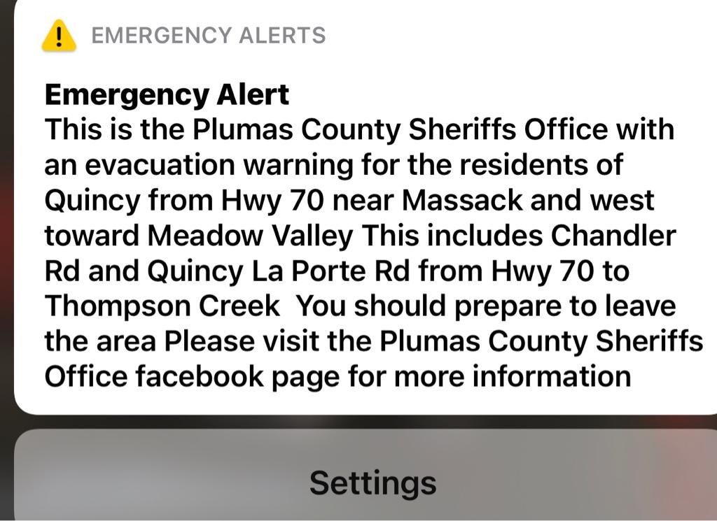
https://ftp.wildfire.gov/public/inc...t_20210723_0141_Dixie_CABTU009205_0723day.pdf
Chewing’ away, making hard push at Quincy now.
Spotted over Hwy 70 yesterday and took off
8ce792f15fc4126a2d53176bdfe0d8b0.jpg


Sent from my iPhone using see
 
The Demon Dog and I are going to be Climate Change refugees and head to the west side to camp on the edge of a hay field. We've been living for a week in Unhealthy air and it ain't getting any better. We leave tomorrow.

Canada just got 100 firefighters from Mexico who will be working to the north of here. The major smoke makers are to the west in the Methow Valley area. Those fires just keep growing. The end is not in sight.
 
I've been seeing a trend by city departments in California to let small grass fires burn if conditions are favorable and exposure risk is minimal
Used to be they rolled up on a median or exit ramp grass fire and just hit it with some water and put it out. Now they are letting it burn and even lighting the rest of it to get it all burned off faster. They roll plenty of units to keep it under control.

I don't know if this new, it's at least new to me. I've only seen it in California so far.
It is a good idea, it won't burn again this season, if you get a firestorm later it offers a safety zone and could even slow the fire.

I have not asked the municipal firemen I know about it yet. Next time I travel down there I'll see what they say about it. I asked my uncle about it, he's retired cal fire, he said it was new to him, but he'd seen it too in the So. Cal area.
 
I was working a grade project yesterday when the two Cal Fire hand crews received a dispatch to the Dixie Fire. I'm scheduled to work with them all next week but I doubt that will happen as they were sent as a strike team. I need to finish my part of the project by December 31st. I'm worried.
 
I've been seeing a trend by city departments in California to let small grass fires burn if conditions are favorable and exposure risk is minimal
Used to be they rolled up on a median or exit ramp grass fire and just hit it with some water and put it out. Now they are letting it burn and even lighting the rest of it to get it all burned off faster. They roll plenty of units to keep it under control.

I don't know if this new, it's at least new to me. I've only seen it in California so far.
It is a good idea, it won't burn again this season, if you get a firestorm later it offers a safety zone and could even slow the fire.

I have not asked the municipal firemen I know about it yet. Next time I travel down there I'll see what they say about it. I asked my uncle about it, he's retired cal fire, he said it was new to him, but he'd seen it too in the So. Cal area.
Seen it plenty of times around Fresno where smoke doesn't affect residents to much. We had a fire in a county flood control area and a crew burned off the access road while engines kept an eye on the homes until they went to put out the hotspots.
 
I just returned home from a place where the air was clear.

When I left, it was unhealthy here, now it is worse. Leaving day, the rating was 148. Today it is 259. Low scores are good. Bah.
 
Dixie fire Situation normal, all ****ed up.
Dennis burns fire behavior analyst summed up the expected situation that was coming yesterday with the weather change with "we hope everything holds"...West zone(Calfire) fire jumped a mile out of mopped up containment lines and is now threatening Chester, the east zone blew out past round valley reservoir and is on the north side of Greenville heading east.
Thermal imaging cameras on dyer mountain east of lake almanor looking west.
https://weathernode.net/flir
 
Not sure what the deal is but this thread won't let me post to the last page -- for days I didn't know how to fix it but I just discovered that I can go to the first page and let the new post get bumped to the end. Is anybody else having this problem?
 

Latest posts

Back
Top