It's a Pacific Northwest thing... you wouldn't understand!

Arborist Forum

Help Support Arborist Forum:

This site may earn a commission from merchant affiliate links, including eBay, Amazon, and others.
<object width="480" height="385"><param name="movie" value="http://www.youtube.com/v/gephLnImzM8?fs=1&amp;hl=en_US&amp;color1=0x2b405b&amp;color2=0x6b8ab6"></param><param name="allowFullScreen" value="true"></param><param name="allowscriptaccess" value="always"></param><embed src="http://www.youtube.com/v/gephLnImzM8?fs=1&amp;hl=en_US&amp;color1=0x2b405b&amp;color2=0x6b8ab6" type="application/x-shockwave-flash" allowscriptaccess="always" allowfullscreen="true" width="480" height="385"></embed></object>

Thats bout the funniest stuff Ive ever seen. :laugh:

He ran that poor lil kid half to death. Wing dat sumbeach!
 
Yes, I have boats and live on a high spot. I don't live behind the bar anymore so if we are cut off, I'll have to drink up my own alcoholic beverages.

The phrase, "Swamp Loggers" was used yesterday. Unfortunately, our version of Swamp Loggers is cancelled due to wet weather. That's up here, in the PNW. :)
 
We are well above average rainfall, lots of snow in the Coast Range, a big Pineapple could give us a flood year, nothing like '64, but the river channels could use washed out.
 
We are well above average rainfall, lots of snow in the Coast Range, a big Pineapple could give us a flood year, nothing like '64, but the river channels could use washed out.

I remember hearing about that one a lot when I worked in Humboldt....crazy how high that water got...I cant believe it washed that bridge out between Fortuna and Rio Dell!
 
It definitely gave the river banks a good cleanin!

images
 
Oh joy.

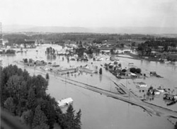
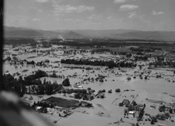
It's Sunday into early next week that we up the ante on the rainfall as forecast models show a long train of tropical moisture taking aim at the Pacific Coast. This is our proverbial "Pineapple Express" fire hose of moisture, but models still are not agreeing on where this hose will aim and how long it'll stick around, but with it in the neighborhood, we need to plan as if it's going to rain heavily non-stop for a couple days and keep an eye for potential river flooding.

I'm hoping the below weather discussion is right, in that the PE warming will be brief. feet. We at least have the benefit of colder ocean temps, typical of a La Nina winter. I'm going to try to get up skiing Friday and Saturday---I've yet to be up, and have a full season's pass to both Crystal and Snoqualmie (Alpental is the real draw there) So far, the current storm hasn't been dumped a huge amount of snow at pass levels, but Baker has received two feet, but that is mighty wet snow,as the water content is 3.2 inches. If the snow levels drop to 2500 as they say today, then skiing tomorrow could be pretty good. If Crystal gets a fair bit more than the paltry 9" in the last two days, I'll head up there.


FXUS66 KSEW 091112 AAA
AFDSEW

AREA FORECAST DISCUSSION...UPDATED
NATIONAL WEATHER SERVICE SEATTLE WA
300 AM PST THU DEC 9 2010

MINOR ADJUSTMENT TO WORDING ABOUT GREEN RIVER IN THE HYDROLOGY
SECTION.

.SYNOPSIS...MOIST WESTERLY FLOW ASSOCIATED WITH A DEEP UPPER LOW IN
THE GULF OF ALASKA WILL KEEP WESTERN WASHINGTON SHOWERY THROUGH
FRIDAY. HEAVY SNOW WILL CONTINUE TO FALL IN THE MOUNTAINS. AFTER A
RELATIVE BREAK LATE FRIDAY AND FRIDAY NIGHT...RAINY AND MILDER
WEATHER WILL DEVELOP OVER THE WEEKEND AND CONTINUE INTO EARLY NEXT
WEEK.

&&

.SHORT TERM...MOIST WEST-SOUTHWEST FLOW CONTINUES ACROSS THE PACIFIC
NORTHWEST ABOUT A DEEP UPPER LOW NEAR 53N/139W. THE AIR MASS REMAINS
SOMEWHAT UNSTABLE WITH SHOWERS WIDESPREAD ACROSS WESTERN WASHINGTON.

THE UPPER LOW WILL WEAKEN AND MOVE SLOWLY NORTH-NORTHEAST TOWARD
SOUTHEAST ALASKA TODAY THROUGH FRIDAY. WEST-SOUTHWEST FLOW WILL
CONTINUE ACROSS WESTERN WASHINGTON TODAY...THEN BECOME MORE WESTERLY
TONIGHT. PLENTY OF MOISTURE WILL CONTINUE TO STREAM INTO THE
FORECAST AREA THROUGH THIS PERIOD...AND THE AIR MASS WILL REMAIN
WEAKLY UNSTABLE. SHORTWAVE FEATURES IN THE ZONAL FLOW WILL MOVE
THROUGH THE REGION...MOST LIKELY ONE TONIGHT AND ANOTHER ONE FRIDAY.

SO THE SHOWERY WEATHER REGIME WILL CONTINUE. THERE HAVE BEEN SOME
THUNDERSTORMS -- ESPECIALLY ALONG THE COAST AND OFFSHORE -- SINCE
TUESDAY NIGHT...AND THAT SHOULD CONTINUE THROUGH TONIGHT. THE SNOW
LEVEL IS AROUND 3500 FT AT THIS TIME...AND IT WILL FALL TO AROUND
2500 FT BY FRIDAY MORNING. THE WINTER STORM WARNING FOR THE
MOUNTAINS LOOKS ON TRACK. ANOTHER 1.0 TO 2.5 INCHES OF PRECIPITATION
CAN BE EXPECTED TODAY THROUGH FRIDAY FOR MOST AREAS IN THE
MOUNTAINS...MEANING ANOTHER 1 TO 2.5 FT OF SNOW IS LIKELY.

ON FRIDAY NIGHT AN UPPER RIDGE WILL BEGIN BUILDING ALONG THE WEST
COAST OF NORTH AMERICA...AHEAD OF A PLUME OF SUB-TROPICAL MOISTURE
MOVING ACROSS THE DATELINE. THE STRONG WARM FRONT ASSOCIATED WITH
THIS WILL REACH THE OREGON COAST FRIDAY NIGHT AND LIFT NORTHWARD
ACROSS WESTERN WASHINGTON SATURDAY AND SATURDAY NIGHT. IT WILL BRING
SUBSTANTIAL PRECIPITATION TO THE AREA. THE SNOW LEVELS WILL RISE
DRAMATICALLY TO AROUND 7000 FT OVER THE OLYMPICS AND SOUTH
WASHINGTON CASCADES SATURDAY NIGHT...BUT REMAIN LOWER FOR THE TIME
BEING OVER THE CENTRAL AND NORTH WASHINGTON CASCADES. MCDONNAL

.LONG TERM...THE STRONG WARM FRONT WILL CONTINUE TO LIFT NORTHWARD
SUNDAY AND SUNDAY NIGHT...WITH THE SNOW LEVEL CLIMBING TO AROUND
7000 FT ACROSS THE ENTIRE FORECAST AREA. THE COLD FRONT ASSOCIATED
WITH THIS SYSTEM WILL MOVE SOUTHEAST ACROSS WESTERN WASHINGTON
MONDAY. IT WILL BRING MORE RAIN BUT THE COOLER AIR MASS BEHIND THE
FRONT WILL BRING THE SNOW LEVEL DOWN TO 2500 FT OR SO ON TUESDAY.

THE COOLER SHOWERY REGIME SHOULD CONTINUE THROUGH THURSDAY. THE
LONGER RANGE MODELS AGREE BROADLY ON THIS SCENARIO. MCDONNAL
 
Last edited:
We are well above average rainfall, lots of snow in the Coast Range, a big Pineapple could give us a flood year, nothing like '64, but the river channels could use washed out.

Even the Flathead Valley here in Montucky flooded bad in '64. I was just an itch in daddy's pants then. . . But I've seen some pictures. :D

Edit:

fig1_7a_1964-Flood-1_flat.jpg


fig1_7b_1964-Flood-2.jpg


The Great Northern Railroad also took a big hit that year: http://www.gnry.net/flood/flood.html
 
Last edited:
rbtree

I'm 3 hours North of you if your in Seattle,just 45 minutes once your over the line.Everyone here has been going bananas buying up snow tires for the big snowfall to come because of El Nina.It's recommended that here that you put on 4 snow tires rather than just the two on the drive wheels so that has added to the frenzy and there is a bit of a shortage for some sizes because Quebec has a law that states 4 snowies on a vehicle.Right now it is absolutely pissing down here.
Lawrence
 
well? are the webbs between your toes coming out? it's supposed to be even better this weekend. rivers should be plenty blownout too.
 
Rain,Rain.Rain

Man, it has poured here today I tell ya.Just about an hour ago we had a brief glimpse of,ah SUN,Yeah SUN.It's supposed to rain for the next four days.
Lawrence
 
Our emergency plan is invoked...

I was asked to work a day this weekend. Since we go out in twos, I picked a coworker who has a family with a lot of heavy equipment. Should we get marooned, I know her hubby will move a lot of earth to get us out.

I'm a team leader, but I'm not sure what that is. It seems as though anybody who is saw certified is a leader, and Twinkle has cut stuff out of a mudslide before, making her and me look like we should both be on one of the "How Do I Get My Saw Clean" threads. Back in da old days, when ve had lots more people aworkin' here, ve vould do such (sometimes stupid) tings like hook chokers to chunks in culverts and try to pull them out wid a 2 wheel drive compact 4 banger pickup. I don't have any chokers now. But I have a bigger pickup.

Oh well, more money will be earned for dentistry. (where's the whiney emoticon?)

From 2007 or was it 2008?
attachment.php
 
i think it was 2007 slowp if i remember right. it was pooring today on tiger mountain the little mini ex was sliding around on the trails witch was fun
 
Well looks like the train is moving north as we down here in the central Sierra's will be in the 70's by the weekend. This is December isn't it. As far as the 64 flood when i lived in Orleans all the locals talked about how Bluff Crick drainage got damned up near the junction with hwy 96 and then blew out and redirected the the whole creek bed into the Klamath. Seen some pretty impressive pics of the Orleans bridge getting hammered too. "The 1964 flood of the Klamath was brought about by a combination of heavy snow pack back in the mountains combined with warm weather and lots of warm pineapple connection rain".
"Water is all powerful when in mass. :bowdown:
 
Last edited:
The 1996 flood brought the Salmon up to the 1964 level or quite close to it. Fortunately, the Klamath did not rise as much. I watched the tail lights of the jeep in front of me disappear on the highway. The road had sunk about 5 feet and the highway stripes were still lined up. He got the jeep out later.

We Somes Barians were cut off for a while. Not even the mail got through.
 
Went through the '66 flood on MT Hood. When we went to sleep is was below freezing and about 3 feet of wet snow on the ground. When we woke up it was above 50 and the snow was gone. School was closed as the water rose. Had to walk across the bridge to get into Rhododendron from the West. Two or so hours later 100 foot on the West and about 250 feet on the East side of the bridge fell into the Zigzag River. My mother was on the West side of the bridge after the approaches fell. three days later she had to ride a bosom's chair across one of the creeks feeding the river to get home.

Watched over 100 houses float down the river and bust up. One family got out with their kids and the Barbie dolls they had for them for Christmas.

I guess the good part is that only one person was killed. Old guy would not leave his home.

Hal
 
The pine apple xpress is here was raining at Crystal yesterday afternoon pouring today rivers are turning brown and raising fast. Thank doodness its supposed to cool bak down tuesday after freezing level up to 8000 feet today.
 

Latest posts

Back
Top