tylerbeach3
fellimbuck spiltn'burn
Wait. THE randymac might come? Cool.


Randy, I'll caravan down with ya if you want!

Am I stopping in Portland on your account as well? Gotta stay on top of stuff, y'know!

Hang in there, y'all, I have been following this story all morning. Looks real bad from here.The Tubbs fire is burning the heck out of NE Santa Rosa as well as areas of Calistoga. It started somewhere near 128 in between Santa Rosa and Calistoga/Saint Helena. Don't at this point know if the park is affected. Good chance that it is. We have falling ash/burned leaves/bark on and around our house SW of Sebastopol. Closest fires are about 10 miles from here. Thoughts and prayers for all the affected people and the park are greatly appreciated. Ckelp (and family) and my Dad live about 2 miles south of the current evacuation zone.
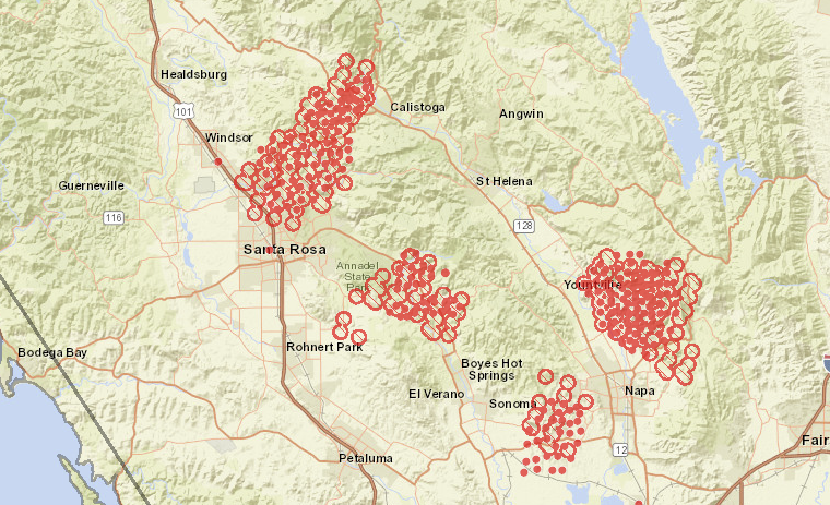
Here's the best map I can find at 1600 09 Oct; this is from 1000, 6 hrs ago. It puts the main body of the fire NE of Bothe-Napa park and SW of RLS Park. The wind is from the NE so this would be a backing fire. Backing fires tend to move slower, but also to burn things in their path more completely due to staying longer. I'll post an updated map when I find one.
Update: this NWCG map should auto-refresh.
Certainly has been a fire country West of Clear Lake.It's several fires at the same time. Worth noting is that just north of there burned hard 2 and 5 years ago. It's definitely fire country, especially this time of year.
Landscape surely will be changed, not sure I want to see it in that state of ruin.I have a feeling things are gonna look a little different when I get there a month from now.
Enter your email address to join: