Are you guys on the East coast getting ready for the Hurricane?

Arborist Forum

Help Support Arborist Forum:

This site may earn a commission from merchant affiliate links, including eBay, Amazon, and others.
Just had a hilarious chat on the phone with my cousin. His wife is starting to go into a bit of a panic mode with the storm.

She says, "I think we should fill the bathtub and some buckets so we'll have water to flush the toilets."

His answer: "Nancy, there's 12,000 gallons out in the pool."

I understand her reasoning. What if you have to flush during the deluge? With water in the tub, you can stay indoors. It is hot here today so I am watching the weather channel. They were pointing out how the rotation of the storm will push water ahead. I would think if it rotated the other way it would push water also. :confused:
 
Indeed everyone is starting to worry! We had both bucket trucks in full tilt all week. There calling up already worrying about there leaners and dying trees. I'm on call Sunday and although its not supposed to be as bad as it could be, $hit is gonna fly! There will be money to be made and if there's two things I love, its ripping saws and money!
 
Come on!!

I just bought 2 more new saws, some files, chains, plugs,gas,oil and am waiting for this to happen!
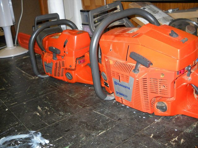
We're used to storms up here!! As long as I'm not out in Georges Bank, where I have been in 50 ft. confused seas, I'm alright. Nhmurph just shipped me a 79cc Makita so I can't wait!!! Sharpened 3 other saws and got some b/c oil and gas. Generator is all ready. So let it happen. Weather guy said barometer in center is rising though so looks like we won't have real strong hurricane winds. We'll see...
 
Living in southern Maine we are expected to get heavy rain with 40-70 mph winds. Are those wind speeds enough to do any damage? Ive never really experienced anything like this.!

I'm down in your neck of the woods. Yes, anything over 50ish will give some damage. With the leaves on the trees, it's even worse. I'd be prepared for a few days without power.
 
we have shipped more than 60 gen sets, 60k to 1 mag in size. and today we donated a whole pallet of saws as well.
 
Been working 16hr days since Weds.
Just spent 16hrs, cleaning up were a tornado skipped around (touched down several times) in a small area.
Snapped, twisted and just mangle trees like I have never seen. Most of the wood is not even good enough for cord wood. Tornado's are RARE around here, and to see it first hand in my back yard is weird. The storm must have pushed the weather upwards enough to get with the front that came in and it brought some crazy isolated weather that will keep us busy putting up wire and poles for at least a week. Sad part we won't really see any direct weather from the big storm. Probably get our area cleaned up and be asked to go east.
 
I say...BRING IT ON!!!!

DSC01213.jpg
 
Storm passed by Charleston SC well out in the Atlantic. No problems here. Guess the Stihls will stay on the shelf again this weekend.
 
Bulletin
hurricane irene intermediate advisory number 28a
nws national hurricane center miami fl al092011
800 am edt sat aug 27 2011

...center of irene makes landfall near cape lookout north
carolina...


Summary of 800 am edt...1200 utc...information
----------------------------------------------
location...34.7n 76.5w
about 5 mi...10 km nne of cape lookout north carolina
about 60 mi...100 km sw of cape hatteras north carolina
maximum sustained winds...85 mph...140 km/h
present movement...nne or 15 degrees at 14 mph...22 km/h
minimum central pressure...952 mb...28.11 inches


watches and warnings
--------------------
changes in watches and warnings with this advisory...

None

summary of watches and warnings in effect...

A hurricane warning is in effect for...
* little river inlet north carolina northward to sagamore beach
massachusetts...including the pamlico...albemarle...and currituck
sounds...delaware bay...chesapeake bay south of drum point...new
york city...long island...long island sound...coastal connecticut
and rhode island...block island...marthas vineyard and nantucket

a tropical storm warning is in effect for...
* south santee river south carolina to little river inlet
* chesapeake bay from drum point northward and the tidal potomac
* north of sagamore beach to merrimack river

a tropical storm watch is in effect for...
* merrimack river to eastport maine

interests in new brunswick and nova scotia canada should monitor the
progress of irene.

For storm information specific to your area in the united
states...including possible inland watches and warnings...please
monitor products issued by your local national weather service
forecast office. For storm information specific to your area outside
the united states...please monitor products issued by your national
meteorological service.


Discussion and 48-hour outlook
------------------------------
national weather service doppler indicates that the eye of irene
made landfall near cape lookout north carolina around 730 am
edt...1130 utc. The estimated intensity of irene at landfall was
85 mph...140 km/h...category one on the saffir-simpson hurricane
wind scale.

At 800 am edt...1200 utc...the center of hurricane irene was located
near latitude 34.7 north...longitude 76.5 west. Irene is moving
toward the north-northeast near 14 mph...22 km/h...and this general
motion is expected to continue for the next 24 hours. On the
forecast track...the center of irene will move across eastern north
carolina today. The hurricane is forecast to move near or over the
mid-atlantic coast tonight and move over southern new england on
sunday.

Maximum sustained winds are near 85 mph...140 km/h...with higher
gusts. Irene is a category one hurricane on the saffir-simpson
hurricane wind scale. Slight weakening is forecast as irene crosses
eastern north carolina...but irene is forecast to remain a
hurricane as it moves near or over the mid-atlantic states and new
england.

Hurricane-force winds extend outward up to 90 miles...150 km...from
the center...and tropical-storm-force winds extend outward up to
260 miles...415 km. A sustained wind of 59 mph with a gust to 84
mph was recently measured at cape hatteras north carolina.

The latest minimum central pressure estimated from data from an air
force reserve hurricane hunter aircraft is 952 mb...28.11 inches.
A coastal marine observing site at cape lookout north carolina
recently reported a pressure of 954.0 mb...28.17 inches.


Hazards affecting land
----------------------
wind...tropical-storm-force winds should spread northward along the
mid-atlantic coast later this morning with hurricane conditions
expected by this afternoon. Hurricane-force winds should spread
northward through the hurricane warning area during the day.
Tropical storm conditions are expected to reach southern new
england tonight with hurricane conditions expected on sunday.

Storm surge...an extremely dangerous storm tide will raise water
levels by as much as 5 to 9 feet above ground level in the
hurricane warning area in north carolina...including the albemarle
and pamlico sounds. Storm surge will raise water levels by as much
as 4 to 8 feet above ground level within the hurricane warning area
from the north carolina/virginia border northward to cape cod
including southern portions of the chesapeake bay and its
tributaries. Near the coast...the surge will be accompanied by
large...destructive...and life-threatening waves. Storm surge
values are very location-specific...and users are urged to consult
products issued by their local national weather service offices.

Rainfall...irene is expected to produce rainfall accumulations of
6 to 10 inches...with isolated maximum amounts of 15 inches...from
eastern north carolina northward through the mid-atlantic states
into eastern new york and western new england. These rains
could cause widespread flooding and life-threatening flash floods.

Surf...large swells generated by irene are affecting portions of the
coast of the southeastern united states. These swells will cause
life-threatening surf and rip current conditions.

Tornadoes...isolated tornadoes are possible over extreme eastern
north carolina today.


Next advisory
-------------
next complete advisory...1100 am edt.

$$
forecaster brown
 
The damage starts about 50 miles east of Raleigh NC from what I've heard

Yes it can

For some reason, I-95 in NC is the designated dividing line for a lot of storms in NC. Sure enough, east of there today there's some damage, and of course the coast got it, but not too badly. We're getting wind and drizzle in Raleigh, but not as severe as the forecast. I think Irene started NE again and is pulling away from here.

You guys north of here hang on and you'll be OK. It's weakening.
 
indeed everyone is starting to worry! We had both bucket trucks in full tilt all week. There calling up already worrying about there leaners and dying trees. I'm on call sunday and although its not supposed to be as bad as it could be, $hit is gonna fly! There will be money to be made and if there's two things i love, its ripping saws and money!
amen!!!
 
Having left Virginia last month I missed the earthquake on Tuesday and the hurricane today. My mother in law has been without power since 11:00 this morning, they now say 1,000,000 without electricity. A member on this site just e-mailed that trees were coming down in Richmond and there were severe wind gusts.
 
Back
Top